 Nyhet
Nyhet Kartor - KARTOR EUROPA
Italien Vägatlas Michelin 2025
295 kr
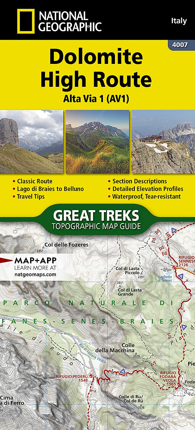
The Alta Via n. 1 (High Route One) of the Dolomites is considered to be the most beautiful classic route in the entire Dolomite territory. It connects Lake Braies with Belluno, winds along a route of approximately 125 kilometers (78 miles), with 7,300 meters (23,950 feet) of altitude difference in 12 stages. The route cuts from north to south and is normally followed starting from Braies. The Alta Via n. 1 crosses five different mountain groups: the Braies Dolomites, the Fanes Group (Fanis), the Ampezzo Dolomites, the Northern Dolomites of Zoldo, and the Southern Dolomites of Zoldo. The Dolomite Topographic Map Guide booklet makes a perfect traveling companion when traversing these routes. A detailed description of each trail section is included that tells travelers about the many landmarks encountered along the way. Every Great Treks map is printed on Backcountry Tough waterproof, tear-resistant paper. A full Lat/Long grid is printed on the map to aid with GPS navigation. Every map purchase helps support the National Geographic Society, an impact driven, nonprofit organization with global reach that uses the power of science, exploration, education, and storytelling to illuminate and protect the wonder of our world.
The Alta Via n. 1 (High Route One) of the Dolomites is considered to be the most beautiful classic route in the entire Dolomite territory. It connects Lake Braies with Belluno, winds along a route of approximately 125 kilometers (78 miles), with 7,300 meters (23,950 feet) of altitude difference in 12 stages. The route cuts from north to south and is normally followed starting from Braies. The Alta Via n. 1 crosses five different mountain groups: the Braies Dolomites, the Fanes Group (Fanis), the Ampezzo Dolomites, the Northern Dolomites of Zoldo, and the Southern Dolomites of Zoldo. The Dolomite Topographic Map Guide booklet makes a perfect traveling companion when traversing these routes. A detailed description of each trail section is included that tells travelers about the many landmarks encountered along the way. Every Great Treks map is printed on Backcountry Tough waterproof, tear-resistant paper. A full Lat/Long grid is printed on the map to aid with GPS navigation. Every map purchase helps support the National Geographic Society, an impact driven, nonprofit organization with global reach that uses the power of science, exploration, education, and storytelling to illuminate and protect the wonder of our world.
| Artikelnummer | 20557_gb |
|---|---|
| Kategori | Kartor - KARTOR EUROPA |
Dolomite High Route Alta via 1 NGS skickas vanligtvis inom 1-2 arbetsdagar. Leveranstiden är normalt 1-3 arbetsdagar efter att paketet skickats. Vid beställningar över 500 kr är frakten kostnadsfri.
Ja, Dolomite High Route Alta via 1 NGS finns i lager och är redo för leverans.
Vi erbjuder 30 dagars öppet köp på alla varor. Produkten ska vara oanvänd och i originalförpackning för att full återbetalning ska ske.
Vi accepterar betalning via Klarna (faktura, delbetalning, direktbetalning), samt kort (Visa och Mastercard). Alla betalningar sker via säker krypterad anslutning.